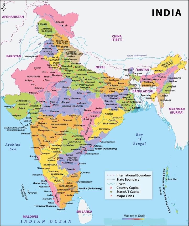
Political Map of India – Download India Political Map With States 2023 PDF
By BYJU'S Exam Prep
Updated on: November 14th, 2023
The Political Map of India displays all the Indian States and Union Territories, including their capital cities. It constitutes 28 states and 8 Union territories. India holds the largest democracy in the world and is considered the world’s second most populated country. The Jammu and Kashmir state has been officially divided into two branches, i.e., Union Territories (UT) of Jammu & Kashmir and UT of Ladakh, since October 2019.
India Political Map is widely used as a reference map, and they help individuals study the country’s topography. A political map can be printed on paper or other physical mediums or created in digital form, suitable for viewing online. This article highlights the modification of the political map of India by the centre after the withdrawal of the unique status given to Jammu and Kashmir under Article 370. Additionally, have a glance at the latest political map of India.
Table of content
Political Map of India 2023
There is some latest news about the political map of India according to the Jammu and Kashmir Reorganisation Act, 2019. This particular bill was presented in the Rajya Sabha on 5th August 2019.
- It aimed to bifurcate Jammu and Kashmir into two Union Territories – Jammu and Kashmir Union Territory and Ladakh Union Territory.
- It changed the number of Indian states, and UTs in India as both the Parliamentary houses consented to the bill.
- This way, India now has 28 states and 8 Union Territories.
- On 26th January 2020, Daman & Diu and Dadra & Nagar Haveli were merged.
☛ States and Union Territories in India

India Political Map – Latest Modifications
Several adaptions in the political map of India took place after the bifurcation of the Jammu and Kashmir state into two Union Territories, which include the following.
☛ Download Latest Political Map of India PDF
Two independent lieutenant Governors oversee both the Union Territories (LG), according to the Jammu and Kashmir Reorganisation Act, 2019.
|
Union Territory of Ladakh |
Union Territory of Jammu & Kashmir |
|
It will include Leh and Kargil districts. |
It consists of the remaining territories of Jammu and Kashmir’s existing state. |
|
It will be without a legislature like Chandigarh. |
It would have a legislature like Puducherry. |
|
The Central government will have direct control of this UT. |
The Centre will be in direct authority of the police and law and order. |
India Political Map with States and Union Territories
Given below is the India map with states and its Union Territories. The number of states and Union Territories have changed after the Jammu and Kashmir Reorganisation Act of 2019.
|
Union Territories |
States |
|
Andaman and Nicobar Islands Chandigarh Dadra and Nagar Haveli & Daman and Diu Delhi Jammu & Kashmir Ladakh Lakshadweep Puducherry |
Andhra Pradesh Arunachal Pradesh Assam Bihar Chhattisgarh Goa Gujarat Haryana Himachal Pradesh Jharkhand Karnataka Kerala Madhya Pradesh Maharashtra Manipur Meghalaya Mizoram Nagaland Odisha Punjab Rajasthan Sikkim Tamil Nadu Telangana Tripura Uttarakhand Uttar Pradesh West Bengal |
Types of Political Maps of India
Political maps show components of the region the map is focused on and help understand how humans interact with a particular region. A political map does not bear any topographic characteristics and demonstrates the location of cities concerning one another.
Some examples of political features that are shown on political maps are
- Country’s border
- Public transportation
- Water bodies
- Small regions
- Roads
- Cities and towns.
India Political Map – Major Divisions
India is a huge country that consists of 28 States and 8 Union Territories, observable in a political map of India. The political division of India has been done in the following ways.
- The division of states and UTs is based on the languages people speak in those regions.
- The country has a Central or Union Government having its capital, New Delhi, which formulates all the rules and regulations for the entire nation.
- India is divided further into smaller regions called States, as Central Government cannot keep an eye on law and order in each part of the country.
- Every state of India has its capital and an elected Government with important officers like the Governor (head of state), the Chief Minister, and other Ministers.
- Union Territories are the areas of the country controlled directly by the Central Government.
Also, Read:
Uses of Political Map of India
Individuals in various Government sectors use political maps of India to understand the political boundaries and their prominent role in decision-making.
- A political map represents where each district starts and ends and how many people live or work there.
- They show diverse communities for municipal services.
- It portrays various geographic boundaries and restricted areas of the country in the northern and southern zones, as well as the ethnic attributes of India from east to west.
- It also illustrates diverse factors of railways, highways, and the network passage that acts as a cultural network linking various parts of the country.
- A political map of India can help define regional socio-political conventions that impact group activity and government results.
