Indira Point: Latitude, Facts | Southernmost Point of India
By BYJU'S Exam Prep
Updated on: November 14th, 2023
The southernmost point of India is called the Indira Point, located in the Nicobar Islands and lies at 6°4′ N latitude. This place has gained much popularity in the last few decades among tourists because of its wide variety of flora and fauna, natural environment with less human interference, etc. Indira point is a village located in the Great Nicobar Island of the Andaman and Nicobar Islands of India and administered by the Laxmi Nagar Panchayat.
Indira Point is also known as Pygmalion Point, which was later named after the former Prime Minister of India, Smt Indira Gandhi, during the mid-1980s, when her son, former PM Rajiv Gandhi, visited the place. Get all information about the southernmost point of India, including its characteristics, interesting facts, latitude, and Indira Point on India Map in this article.
Table of content
Indira Point – Southernmost Point of India
The Indira Point was made open to the public on April 30, 1972. The history of this southernmost point of India is marked by a tragic incident where 16 to 20 families living near the lighthouse and 4 scientists researching leatherback sea turtles were lost after an earthquake hit the region, followed by a tsunami.
Indira Point PDF
In 2004, an earthquake hit the Indian Ocean, and the southernmost tip of India (Indira point), located 500 kilometers north of the epicenter, sank 4.25 meters into the water.
Where is Indira Point located?
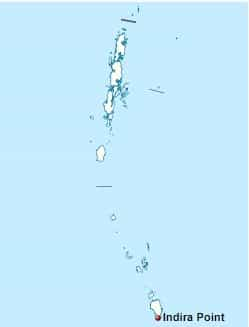
Indira Point is located in Andaman and Nicobar Islands. Many people have a misunderstanding of this point being located in the Kanyakumari region. From Sumatra, Indonesia, it is only 150 km away. To get a better understanding of the location of the Southernmost point of India, read the following points:
- It lies 163 km away from Indonesia’s Rondo Island.
- Indira Point is located in the Great Nicobar tehsil.
- The longitude and latitude of this point are 93°48’85” E and 6°45’38” N, respectively.
Interesting Facts about Indira Point
Indira point is not only the south of the Great Nicobar Islands but the southernmost point of the Indian territory. Here, it is important to note that the southernmost point of the Indian mainland is Kanyakumari, located at the Sangam of the Arabian Sea, the Bay of Bengal, and the Indian Ocean. But when it comes to the territory that comes under the Union of India, the Indira point is the southernmost point of India. Check out some interesting facts about Indira point listed below:
- Previously, it was known as the Pygmalion Point.
- It lies in Campbell bay on Great Nicobar Island and is only 150 km away from Sumatra, Indonesia.
- It is named Indira Point after former PM Indira Gandhi visited the lighthouse in 1984. On 10 October 1985, the official name-changing ceremony took place.
- Indira Point got submerged in water by 4.25 meters during the 2004 tsunami. But gradually, the point rises again to its actual height.
- This southernmost point of India is located on the Great Nicobar Island, with a significant population of green turtles, leatherbacks, and hawksbills.
- The famous lighthouse was on high ground before the tsunami, but now it is underwater by 3-4 meters.
- At present, the local administration is trying to connect the Campbell Bay Area with Indira Point, the Southernmost tip of Indian Territory.
Other crucial details about the Indira point are presented in the following table:
|
Criteria |
Details |
|
Located in |
Great Nicobar Tehsil, Andaman and Nicobar Islands |
|
Submerged in water in |
2004 |
|
Indira Point Latitude |
6°45’38” N |
|
Longitude |
93°48’85” E |
|
Other Names |
Pygmalion Point Parsons Point |
Southernmost Point of India
Kanyakumari, located in Tamil Nadu state, is the southmost point of the Indian mainland. But if the entire Indian territory is considered, then the Indira point, located in Andaman and Nicobar Islands, is the southernmost point of India.
- Parsons Point and Pygmalion Point were the other names of this point.
- After Indira Gandhi visited this place in 1984, it was renamed Indira Point through an official ceremony on 10 October 1985.
- Lighthouse and Galathea National Park are two major attractions of this place.
- As per the 2011 census, there are only 4 households left on Indira Point, and the literacy rate of the population over 6 years of age is 85.19%.
Indira Point on Map
Indira point on India Map can be identified as the southernmost tip of the Andaman and Nicobar Islands. The latitude of this place is 6°45’38” N, while the longitude is 93°48’85” E. Look at the following map to locate Indira Point:

