Mizoram District: Mizoram is a northeastern state spread across a total area of 21,081 square kilometres. The state was established as a state on 20 February 1987 and is one of the Seven Sisters states in India. There is a fixed administrative structure in Mizoram, dividing the state into 11 districts and many subdivisions.
Earlier, there were only 5 districts in the state but now, the total number of Mizoram districts is 11. We have shared the names of all the districts of the state, along with a district map of Mizoram here.
How Many Districts in Mizoram?
There are a total of 11 Mizoram districts. Mizoram was established as a union territory on 21 January 1972. At that time, there were only three districts in the state: Aizawl, Chhimtuipui and Lunglei. However, on 20 February 1987, the Indian government declared Mizoram as an official state. Eventually, the number of Mizoram districts also increased to 11.
Number of Mizoram Districts | 11 |
Total Area | 21,081 sq km |
Total Population | 1,091,014 |
Formed In | 1987 |
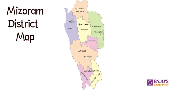
Mizoram Map with Districts
After finding out how many districts in Mizoram are there, knowing details such as the geographical location of these districts is also important. It can help in becoming more familiar with the districts. We have shared the district map of Mizoram here.
Mizoram District List
The list of Mizoram districts has been shared here. Find out the names of all 11 districts of the state here. It is to be noted that the names of the headquarters of each district have also been shared. Check out the Mizoram district list here.
# | Mizoram District | Headquarters |
1 | Aizawl | Aizawl |
2 | Champhai | Champhai |
3 | Hnahthial | Hnahthial |
4 | Khawzawl | Khawzawl |
5 | Kolasib | Kolasib |
6 | Lawngtlai | Lawngthlai |
7 | Lunglei | Lunglei |
8 | Mamit | Mamit |
9 | Saiha | Saiha |
10 | Saitual | Saitual |
11 | Serchhip | Serchhip |
Mizoram Districts - Demographics (Area, Population)
We have presented information about the demographics of all Mizoram districts here. Find out the total area, total population and year of formation of each Mizoram district here.
Mizoram District | Area (sq km) | Population (2011) | Established |
Aizawl | 3,577 | 400,309 | - |
Champhai | 3,185 | 32,734 | 1998 |
Hnahthial | - | 28,486 | 2019 |
Khawzawl | - | - | 2019 |
Kolasib | 1,386 | 83,955 | 1998 |
Lawngtlai | 2,557 | 1,17,894 | - |
Lunglei | 4,572 | 161,428 | - |
Mamit | 3,025 | 86,364 | 1998 |
Saiha | 1,399 | 56,574 | 1998 |
Saitual | - | - | 2019 |
Serchhip | 1,422 | 64,963 | 1998 |
Mizoram District Map
Find out the geographic location of all the Mizoram districts on the map shared here. It will also give you a better idea of the size of the districts of the state. Check out the image for the List of Districts Present Today in Mizoram State.

FAQs on Mizoram Districts
Q1. How many districts are there in Mizoram?
There are a total of 11 Mizoram districts. Mizoram was established as an independent Indian state on 20 February 1987. Originally, there were only 3 Mizoram districts. Each district in the state is governed by a Collector or District Magistrate, who serves in the office of the Indian Administrative Service.
Q2. Which is the largest district in Mizoram?
The largest Mizoram district is Lunglei, which covers an area of 4,572 square kilometres. Lunglei was one of the original three Mizoram districts. This district is also the second most populous district in Mizoram after Aizawl. The total population living in Lunglei is estimated to be 161,428.
Q3. What are the names of the 11 Mizoram districts?
The names of the 11 Mizoram districts are Aizawl, Hnahthial, Kolasib, Lunglei, Saiha, Serchhip, Champhai, Khawzawl, Lawngtlai, Mamit and Saitual. Each Mizoram district is further divided into subdivisions and other lower-level bodies so that the administration can run smoothly.
Q4. Which is the most populated district in Mizoram?
The most populated Mizoram district is Aizawl. As per the 2011 population census, the total population living in Aizawl is 400,309. Aizawl was one of the 3 original Mizoram districts and covers a total area of 3,577 square kilometres. The headquarters of this district are located in Aizawl city.
Q5. Where can I find the list of districts in Mizoram?
The list of Mizoram districts has been shared here. You can check out the list to know the names of all 11 districts of Mizoram. Additionally, we have also shared the demographic details such as the total area, total population and year of formation of each Mizoram district.


