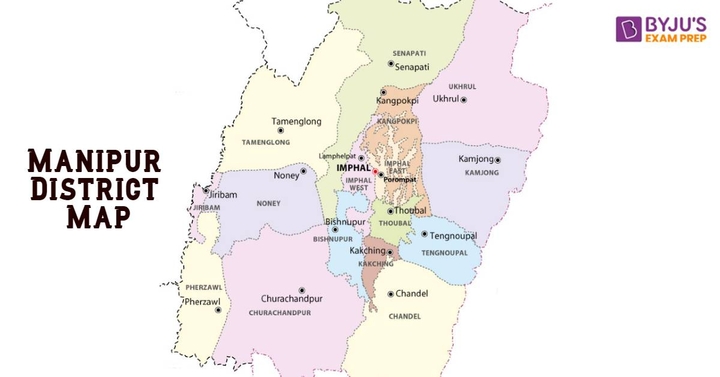
As of 2023, the number of Districts of Manipur is 16. Manipur is a state in northeastern India which covers a total geographical area of 22,327 square kilometres. Initially, Manipur only had 9 districts. However, in December 2016, the Manipur Cabinet announced the creation of 7 new districts in the state.
We have shared the names of all the old and new districts of Manipur here. Moreover, we have also shared the demographics such as the total population and total area covered by the districts of Manipur.
How Many Districts in Manipur
There are 16 districts in Manipur. Until 2016, there were only 9 districts in the state, namely, Thoubal, Imphal East, Imphal West, Bishnupur, Ukhrul, Senapati, Tamenglong and Chandel. However, in 2016, 7 new Manipur districts were added by the State Cabinet to ease the administrative affairs in the state.
The new districts of Manipur that were added in 2016 by the Cabinet are Kamjong, Kakchinf, Jiribam, Noney, Tengnoupal, Kangpokpi and Pherzawl. To create these districts, the existing hill districts of Manipur were bifurcated into the following
- Churachandpur district was bifurcated into Pherzawl and Churachandpur.
- Tamenglong district was carved into Noney and Tamenglong districts.
- Senapati district of Manipur was carved into Kangpokpi and Senapati districts.
- Ukhrul district was bifurcated into Kamjong and Ukhrul districts.
- Chandel district was bifurcated into Tengnoupal and Chandel districts.
Manipur District List
Check out the names of all the existing districts of Manipur here. Each district in the state has a dedicated headquarters. We have also shared the names of the headquarters of each Manipur district in the table below
# | District of Manipur | Headquarters |
1 | Bishnupur | Bishnupur |
2 | Chandel | Chandel |
3 | Churachandpur | Churachandpur |
4 | Imphal East | Porompat |
5 | Imphal West | Lamphelpat |
6 | Jiribam | Jiribam |
7 | Kakching | Kakching |
8 | Kamjong | Kamjong |
9 | Kangpokpi (Sadar Hills) | Kangpokpi |
10 | Noney | Noney |
11 | Pherzawl | Pherzawl |
12 | Senapati | Senapati |
13 | Tamenglong | Tamenglong |
14 | Tengnoupal | Tengnoupal |
15 | Thoubal | Thoubal |
16 | Ukhrul | Ukhrul |
Districts of Manipur - Demographics
Here, you can check the details about the demographics of each district of Manipur, such as the area covered and total population. Go through the table below to find out more details about the 16 districts of Manipur
Districts of Manipur | Area (km²) | Population (2011) |
Bishnupur | 496 | 240,363 |
Thoubal | 514 | 420,517 |
Imphal East | 710 | 452,661 |
Imphal West | 519 | 514,683 |
Senapati | 3,269 | 354,772 |
Ukhrul | 4,547 | 183,115 |
Chandel | 3,317 | 144,028 |
Churachandpur | 4,574 | 271,274 |
Tamenglong | 4,391 | 140,143 |
Jiribam | 232 | 43,818 |
Kangpokpi (Sadar Hills) | - | - |
Kakching | - | 135,481 |
Tengnoupal | - | - |
Kamjong | 2,000 | 45,616 |
Noney | - | - |
Pherzawl | 2,285 | 47,250 |
Manipur District Map
Find out the geographic location of all the Manipur districts on the map shared here. It will also give you a better idea of the size of the districts of the state. Check out the image for the List of Districts Present Today in Manipur State.

FAQs on Districts of Manipur
Q1. How many districts are there in Manipur?
There are a total of sixteen districts in Manipur. Until 2016, there were only nine districts in the state. However, the Manipur Cabinet announced that seven more districts would be created in the state by bifurcating some of the existing hilly districts of Manipur.
Q2. What are the names of the 16 districts of Manipur?
The Indian state of Manipur has 16 districts in total. The names of the 16 districts of Manipur are Bishnupur, Churachandpur, Jiribam, Imphal East, Kamjong, Senapati, Imphal West, Tengnoupal, Ukhrul, Thoubal, Noney, Pherzawl, Chandel, Kakching, Tamenglong and Kangpokpi.
Q3. Which is the newest district in Manipur?
In 2016, 7 new districts were created in Manipur. These districts were carved out of some of the existing hill districts of Manipur. The hill districts were bifurcated to form the new districts in the state. The names of the new districts in Manipur are Kamjong, Kakching, Jiribam, Pherzawl, Kangpokpi, Tengnoupal and Noney.
Q4. Which are the largest and smallest districts in Manipur?
In terms of area, the largest district of Manipur is Churachandpur, which covers 4570 square kilometres of area. On the other hand, the smallest district of Manipur is Bishnupur, which only covers an area of 496 square kilometres.
Q5. Where can I get the list of districts of Manipur?
You can find the list of districts of Manipur here. We have shared the names of all the old and new Manipur districts, along with the names of their dedicated headquarters. You can also find details of the demographics of all of the districts of the state.


