Time Left - 01:00:00 mins
Complete Surveying Marathon Quiz
Attempt now to get your rank among 130 students!
Question 1
The type of surveying in which the curvature of the earth is taken into account is called
Question 2
The method of computing areas by subdividing a plot into triangles is suitable for
Question 3
Curvature correction to a staff reading in a differential leveling survey is
Question 4
Reciprocal levelling was done between two points A and B, the readings of which are as shown below, which are 700 mm apart.
If the atmospheric conditions do not change during the period of observation and R.L. of A is 126.49 m, then the R.L. of B is _______ m.
Question 5
The following readings have been taken from a page of an old level book. The R.L of first station, when R.L of last station is 123.85 m, is ___________ decimeter.

Question 6
The following observation were taken with a tacheometer at the station A to a staff at B held normal to the line of sight. If staff readings are 2m, 3m, & 4m and the angle of inclination is 23 ̊30’. Determine horizontal distance between A and B. also what is the RL of B if RL of A is 200m. Take K=100, C =0.6 & H.I.=1.46m
Question 7
An instrument was set up at a point 200 m away from a transmission tower. The angle of elevation to the top of the tower was 33 °40' whereas the angle of depression to the bottom was 4 °10'. The total height of the transmission tower is _______ m.
Question 8
In order to neutralize the curvature effect and refraction effect, the type of levelling adopted is__________
Question 9
Which one of the following statements are true?
i. Terrestrial photography gives mostly oblique photographs
ii. Aerial photography always gives perfectly vertical photographs
Question 10
For a vertically held staff, if the angle of elevation is 300 and horizontal distance between observer and staff station is 100 m. staff intercept will be-
(take multiplying constant = 100 & additive constant = 30)
(take multiplying constant = 100 & additive constant = 30)
Question 11
Two straight lines intersect such that deflection angle of 60 °. The radius of a curve joining the two straight lines is 600m. The length of long chord and mid-ordinates in metres of the curve are
Question 12
If the sensitivity of the bubble tube of a level is 30" of arc per division, then the distance of a point at which the combined curvature and refraction corrections become numerically equal to the error induced by dislevelment of one division of the level tube (in m) is
Question 13
The magnetic bearing of a line AB is S 45 ° E and the declination is 5 ° west. The true bearing of the line AB is
Question 14
The magnetic bearing of a line AB was N 59 ° 30’W in the year 1967, when the declination was 4 ° 10’ E. If the present declination is 3 ° W, the magnetic bearing in terms of WCB of the line is
Question 15
A leveling is carried out to establish the Reduced Levels (RL) of point R with respect to the Bench Mark (BM) at P. The staff readings taken are given below:
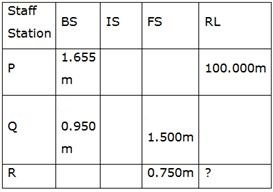
If RL of P is + 100.000m, then RL (in m) of R is
If RL of P is + 100.000m, then RL (in m) of R is
Question 16
In a survey work, three independent angle, X, Y and Z were observed with weight WX, WY, Wz respectively. The weight of the sum of angles X, Y and Z is given by:
Question 17
A bench mark has been established at the soffit of an ornamental arch at the known elevation of 100.0 m above mean sea level. The back sight used to establish height of instrument is an inverted staff reading of 2.105 m. A forward sight reading with normally held staff of 1.105 m is taken on a recently constructed plinth. The elevation of the plinth is
Question 18
The horizontal distance between two stations P and Q is 100 m. The vertical angles from P and Q to the top of a vertical tower at T are 3 ° and 5 ° above horizontal, respectively. The vertical angles from P and Q to the base of the tower are 0.1 ° and 0.5 ° below horizontal, respectively. Stations P, Q and the tower are in the same vertical plane with P and Q being on the same side of T. Neglecting earth’s curvature and atmospheric refraction, the height (in m) of the tower is
Question 19
From a topographic map, the areas enclosed by contour lines for a proposed dam are given below.

The volume of impounded water, using trapezoidal formula, is ______ ha.m.
The volume of impounded water, using trapezoidal formula, is ______ ha.m.
Question 20
A derived quantity's' is given by
s = (4.86)2
The maximum error in 's' is
s = (4.86)2
The maximum error in 's' is
Question 21
The areas within the contour lines at the site of reservoir are as follow:

Take 201 as bottom level of reservoir and 205 as top level, the difference in capacity of reservoir calculated according to trapezoidal and prismoidal method is ________ m3.
Take 201 as bottom level of reservoir and 205 as top level, the difference in capacity of reservoir calculated according to trapezoidal and prismoidal method is ________ m3.
Question 22
Group I lists tool/instrument while Group II lists the method of surveying. Match the tool/instrument with the corresponding method of surveying.
Group–I
P. Alidade
Q. Arrow
R. Bubble tube
S. Stadia hair
Group–II
1. Chain surveying
2. Levelling
3. Plain table surveying
4. Theodilite surveying
Group–I
P. Alidade
Q. Arrow
R. Bubble tube
S. Stadia hair
Group–II
1. Chain surveying
2. Levelling
3. Plain table surveying
4. Theodilite surveying
Question 23
Following bearings are observed while traversing with a compass.
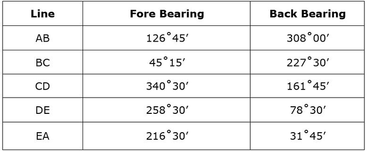
After applying the correction due to local attraction, the corrected fore bearing of line BC will be:
After applying the correction due to local attraction, the corrected fore bearing of line BC will be:
Question 24
The plan of a map was photo copied to a reduced size such that a line originally 100mm, measures 90mm. The original scale of the plan was 1:1000. The revised scale is
Question 25
A box sextant has the main scale readings in 10' graduations. If the least count desired for an extended vernier is 10", then 'M' spaces of the main scale should be equal to 'N' spaces of the vernier scale. The value of M and N are respectively.
- 130 attempts
- 1 upvote
- 0 comments
Tags :
ESE & GATE CESurveyingJan 14ESE & GATE CE

