
- Home/
- SSC & Railways/
- SSC CGL/
- Article
Landforms Created by River and Glacier System, Geography Notes PDF
By BYJU'S Exam Prep
Updated on: September 25th, 2023

Landforms Created by River and Glacier systems are an essential part of the world’s geography. They play a major role in how the land is perceived and how it is used. The landforms created by rivers are extremely important as they create the terrain on the surface of the earth. There can be major and minor landforms, however, all our essential to understand if one is interested in Geography.
Erosion and deposition are the two most common methods through which different landforms are created. Knowing how landforms are created by rivers and glacier systems is essential, especially if you are preparing for SSC or RRB exam. In this article, we have provided complete information regarding the Landforms created by River and Glacier system. So, scroll down!
Table of content
What are Landforms?
A landform is a feature of the Earth’s surface that is part of the landscape. Each landform is distinct in terms of physical shape, size, and materials, and it is the result of specific geomorphic processes and agent(s). Because most geomorphic processes and agents are slow, the results take a long time to manifest. Every landform has a beginning, and once created, landforms can alter shape, size, and character throughout time due to the ongoing activities of geomorphic processes and agents.
Landforms Created by River and Glacier PDF
There are various types of landforms on the surface of the earth. All of them are formed because of different reasons. A majority of landforms are created by rivers. There are also many landforms created by glaciers as well. Knowledge of various types of landforms will help in improved knowledge of overall geography. In addition, questions from this topic are also common in SSC exams. Hence, we are providing detailed notes about the same below.
Landforms Created By River PDF
We have covered all important information regarding the topic of Landforms created by rivers. Candidates can download this PDF and access it anytime to gain insights into the landforms created by rivers and glaciers.
Types of Landforms
Forces both inside and outside the earth can change the form of the planet’s surface. Endogenic and exogenic factors can both build landforms. A landform is a natural feature on the solid surface of the Earth. Examples include mountains, plateaus, and plains.
Mountains: Mountains cover over 27% of the world’s land surface. Up to 80% of the world’s fresh surface water originates in the mountains. According to the Food and Agriculture Organisation of the United Nations (FAO), around 12% of the world’s population lives in mountains, while more than 50% is directly or indirectly dependent on mountain resources.
Plateaus: A plateau is an elevated terrain with relatively level land on top. It has a vast top surface and a steep slope on its sides. They are also known as the high plains or the tablelands. Plateaus cover around 18% of the earth’s land surface.
Plains: Plains are the most common landforms on the planet’s surface. A Plain is a low-lying, relatively flat land surface with a gradual slope and little local relief. Plains cover around 55% of the earth’s land surface. The majority of the plain was formed by the deposition of sediments carried down by rivers. Aside from rivers, certain plains have been generated by wind, sliding glaciers, and tectonic activity.
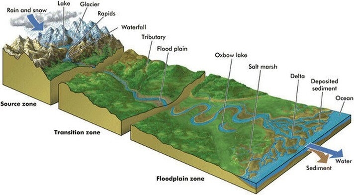
Landforms Created by River
Water is regarded as the most important geomorphic factor in causing the degradation of the ground surface in humid locations with heavy rainfall. The majority of running water erosional landforms are connected with energetic and young rivers flowing over steep grades.
Also Check, Rivers in India SSC Notes
Potholes
These are the deep natural underground cave formed by the erosion of rock, especially by the action of water. These currents erode the river’s bed and create small depressions in it.
- These are drilled into the bed of a river and are cylindrical in nature.
- The diameter and depth vary from a few centimeters to meters.
- These are formed due to the whirling impact of the water current in the upper course of the river.
- In India, the potholes can be observed in the river bed of the Kukadi, Krishna, and Godavari rivers in Maharashtra.
V-Shaped Valley
In mountain ranges, you will find these types of valleys. V-Shaped valleys are deep river valleys with steep sides that look like the letter V, a diagram shown below will give you a better understanding.
- V-shaped valleys have steep valley walls with narrow valley floors.
- These are generally formed by the result of erosion and withering by fast-flowing rivers and are generally formed in the upper course of the river.
- A deep and narrow valley with steep sides is called a Gorge.
- Many gorges are found in river Ulhas in Thane district in Maharashtra and the gorge of the river Narmada at Bhedaghat near Jabalpur in Madhya Pradesh is well known.
Canyon
A canyon has steep step-like side slopes and can be as deep as a gorge. A canyon is wider at the top than it is at the bottom. In actuality, a canyon is a type of gorge. Canyons are frequently formed in horizontally bedded material.
Waterfalls (Geological)
Waterfalls are formed due to the erosion of both hard rock and soft rock. As the river flows over the resistant rock, it falls onto the less resistant rock, eroding it and creating a greater height difference between the two rock types, producing the waterfall.
- Over thousands of years, the repeated collapse of the caprock and retreat of the waterfall produces a gorge of recession.
- Waterfalls exist because of the difference in rock types. When a river flows, it passes through many different rock types and when a river passes from a resistant rock bed to a softer one, it erodes the softer one very quickly and at the junction between the rock types, it steepens its gradient.
- The highest waterfall in the world is Angel Falls in Venezuela (~800 m).
- The largest waterfall is the Chutes de Khone (Khone Falls) on the Mekong River in Laos.
- The Niagara Falls on the river Niagara and Jog Falls in Karnataka on the Sharavathi River are famous waterfalls.
Meanders and Ox-bow Lakes
Meanders are bent in a river that forms as a river’s sinuosity increases. A meander forms when moving water in a stream erodes the outer banks and widens its valley, and the inner part of the river has less energy and deposits silt.
- Meanders form a snake-like pattern as the river flows across a fairly flat valley floor.
- The sinuosity of a river is a measurement of how much a river varies from a straight line.
- Meanders are formed due to lateral erosion and as the erosion increases over a period of time, the meanders in the river again start flowing in a straight line.
- Meander formation is a self-intensifying process where a greater curvature results in more erosion of the bank which in turn results in greater curvature.
- Oxbow lakes are an evolution of meanders that undergo extensive deposition and erosion
- When the meanders cut from the main course and water accumulates in this pool then it resembles the shape of the oxbow.
Fan-shaped Plains
These are found in the region where the Tributaries Rivers join the main river. Fan-shaped plains are landforms that are formed due to the deposition of material carried by the Tributaries Rivers. These flows come from a single point source at the apex of the fan, and over time move to occupy many positions on the fan surface. This deposition resembles the shape of a Fan like plains
Flood Plains
These are formed due to the overflows of the river and floods in the nearby areas. It is an area of low-lying ground adjacent to a river, formed mainly of river sediments and subject to flooding.
- Floodplains are made by downstream traveling meanders.
- Slit carried by the water gets deposited in flooded areas and forms flat plains on both sides of the river.
- The Gangetic Plain is a floodplain.
Levees
It is an embankment built to prevent the overflow of a river by a ridge of sediment deposited naturally alongside a river by overflowing water. When a river floods, it deposits its load over the flood plain due to a dramatic drop in the river’s velocity as friction increases greatly. Repeated floods cause the mounds to build up and form levees.
Delta
Delta is a term coined by Herodotus (The Father of History) after the Greek letter Delta because of the deltoid shaped at the mouth of the Nile River. A River delta is a landform that forms from the deposition of sediment carried by a river as the flow leaves its mouth and enters slower-moving or standing water.
- This occurs when a river enters an ocean, sea, estuary, lake, reservoir, or (more rarely) another river that cannot transport away the supplied sediment.
- Over a period of time, this deposition builds the characteristic geographic pattern of a river delta.
- The Sunderbans delta of the Ganga River is the largest in the world.
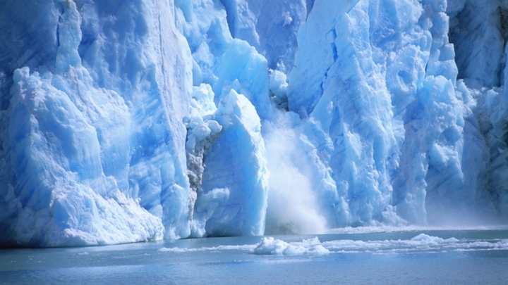
What is Glacier?
A glacier is a persistent body of dense ice that is constantly moving under its own weight; it forms where the accumulation of snow exceeds its ablation over many years. On an average day, a glacier moves 1 to 15 meters a day and there are two types of glaciers, Continental Glaciers and Alpine or Mountain Glacier.
Glacial Landforms
Glacial landforms are those created by glaciers. The majority of modern glacial landforms are the product of massive ice sheets migrating throughout the Quaternary glaciations. Glacial landforms can still be found in areas without active glaciers or glaciation processes. A straight row of stakes laid across a glacier would gradually bend as they descend the valley, implying that the glacier moves quicker in the center than at the outside.
Types of Glacial Landforms
Glaciers form where there is more snowfall than melts each year. When snow falls, it instantly starts to compress or thicken and become more firmly packed. Firnification is the process by which snow condenses into glacial firn (thick, granular ice). When the ice thickens to around 50 meters (160 feet), the firn grains join together to produce a massive mass of solid ice. The glacier begins to calve as a result of its weight.
A glacier’s many components move at varying rates. The flowing ice of the glacier advances faster than the glacier’s base. There are majorly two types of Glacial Landforms Depositional and Erosional.
Glacial Deposition
Glaciers have substantially impacted landscapes in mid and high-latitude alpine regions. The primary glacial depositional landforms are as follows:
- The Drumlins: These flat, oval-shaped topographies mimic ridges and are composed primarily of glacial till with minor amounts of gravel and sand. It forms as a result of glacier fissures that enable rock debris to slide beneath heavily weighted ice. Drumlins’ long axes run parallel to the direction of ice movement. Drumlins depict the movement of glaciers. The Stoss end, the steeper of the two ends, is used to face the ice flow.
- Esker: The esker is one of the most stunning landforms formed by fluvioglacial deposits. They are frequently built of gravel and washed sand. The eskers vary in size and shape. When glaciers melt, water seeps down their edges or flows on top of the ice. These waters pool beneath the glacier and flow through a passage beneath the ice-like streams. These streams are produced by ice and flow above the ground. When the ice melts, very coarse objects like stones and blocks, along with a few small particles of rock debris, settle down in the valley of ice beneath the glacier and become visible as the curving ridge known as Esker.
- Glacial Till: Glacial till is the unsorted coarse and fine debris released by meltwater glaciers. There is some rock debris swept down and deposited that is small enough to be carried by melt-water streams. Outwash deposits are glacial fluvial deposits. The outwash sediments are varied and layered.
Glacial Erosion
Glacial Erosion is caused by two major reasons which include Plucking and Abrasion. It is a process that is known to move the ice which is on the bed of the glacier. The pressure on the ice can make the glacier flow across the water body near which it is situated. Glacial Erosion also causes the glaciers to melt which is extremely harmful to our environment. It has an adverse impact on the climate and is also one of the reasons for the rise of sea levels.
Erosional Landforms by Glaciers
There are three major types of erosional landforms created by glaciers. These landforms are created when the ice on the glaciers moves from their bed. It can cause major geographical changes in the area as new landforms are created. Major Glacial Erosion Landforms are provided below.
Cirque
It is a half-open steep-sided hollow at the head of a valley or on a mountainside, formed by glacial erosion. Cirques are created by glaciers, grinding an existing valley into a rounded shape with steep sides.
- The back wall of the cirque is like a high cliff and the floor is concave and huge in size. The total shape resembles an armchair.
- When a glacier melts completely, water accumulates in the cirque and forms a lake which is known as a tarn.
Hanging Valley
It is a valley that is cut across by a deeper valley or a cliff. Hanging Valley Landforms Have 2 Main Characteristics – a valley that leads to another valley below and A cliff or steep wall below the meeting point
- Hanging valleys are often associated with valley glaciers, joining the main valley along its sides.
- They are the product of different rates of erosion between the main valley and the valleys that enter it along its sides.
- The tributaries are left high above the main valley, hanging on the edges, their rivers and streams entering the main valley by either a series of small waterfalls or a single impressive fall
Aretes and Horns
Aretes, which are glacial landforms, are usually seen between two perpendicular circles. These U-shaped valleys were scoured by glaciers, leaving knife-edged slopes behind.
- The glaciers erode the bedrock beneath these valleys even more, resulting in aretes at the upper reaches of the parallel valleys. Between aretes between two cirques, there is typically a low area called a col.
- A number of cirques are typically clustered radially on the sides of larger mountain ranges, such as the Alps.
- When glaciers wear down the higher regions of these mountain ranges, they form sharp peaks.
- These pointed peaks, nicknamed horns, are surrounded by vertical headwall cliffs divided by aretes.
U-shaped Valley
U–shaped valleys, or glacial troughs, are formed by the process of glaciation. They are characteristic of mountain glaciation in particular. They have a characteristic U shape, with steep, straight sides and a flat bottom.
- As the erosion of the sides is greater than that of the floor, a valley is formed with vertical sides and a wide floor. This valley is called a U-Shaped valley.
- These valleys can be several thousand feet deep and tens of miles long.
- As a glacier moves downhill through a valley, usually with a stream running through it, the shape of the valley is transformed. As the ice melts and retreats, the valley is left with very steep sides and a wide, flat floor. This parabolic shape is caused by glacial erosion striving to decrease friction as much as possible
Fjord
Geologically, a fjord is a long, narrow inlet with steep sides or cliffs, created by glacial erosion. Fjords are common in Norway, Greenland, and New Zealand
We hope this post was useful for you all in understanding the major landforms created by rivers and glaciers. Especially, for candidates preparing for the SSC exam, we hope, this post was helpful. For more such notes and information refer to BYJU’S Exam Prep SSC online coaching to prepare efficiently for the upcoming exams.

