Drainage System of India
What is the drainage system?
- Drainage refers to the channel of a river system in an area.
- Drainage Basin refers to an area which is drained by one river system, i.e. Main River along with its tributaries.
- Drainage system refers to the group of channels of drainages, i.e. channels of main (original) river and its tributaries.
- The function of time of the geological period determines the characteristics of the drainage pattern.
- The major characteristics of drainage pattern are – topography, slope, amount of water flow, nature and structure of rocks.
Drainage Patterns
- Drainage patterns are formed based on the channel and shape of rivers which forms a part of the drainage basin.
- Based on the formation of river patterns the drainage patterns are classified into two types – Discordant and Concordant Drainage Pattern.
Discordant Drainage Pattern
- In Discordant drainage pattern, the rivers will not change its path according to the change in topography or landform in an area.
- The discordant drainage pattern further divided into two types :
- Antecedent and
- Superimposed drainage pattern
- Example: R. Indus, R. Brahmaputra, etc.,
Concordant Drainage Pattern
- In Concordant drainage pattern, the rivers will change its path in accordance with the slope and topography of a region.
- The concordant drainage patterns are further divided into:
1. Consequent rivers
2. Subsequent rivers
3. Dendritic Drainage pattern
4. Trellis Drainage Pattern
5. Radial Drainage Pattern
6. Centripetal Drainage Pattern - In consequent rivers, the rivers flow through the general slope of an area. Mostly main (original) rivers have this drainage pattern. Eg: R. Godavari, R. Cauvery, etc.
- In Subsequent rivers, the tributary streams are formed after the formation of the original stream by the vertical and lateral erosion along the slope. Eg: R. Ken, R. Chambal. Etc.
- In Dendritic Drainage pattern, the pattern of flow of the original river and its tributaries looks like branches of a tree. Eg: R. Indus, R. Mahanadi, R. Godavari, etc.,
- In Trellis Drainage Pattern the tributaries (Subsequent rivers) joins the original river at right angles and the tributaries flow parallel to each other.
- In Radial Drainage Pattern the rivers originate from a common area and flow in all direction from the source region. Eg: Amarkantak Plateau
- In Centripetal Drainage Pattern rivers from different directions drains into a common area. Eg: Loktak Lake, Manipur.
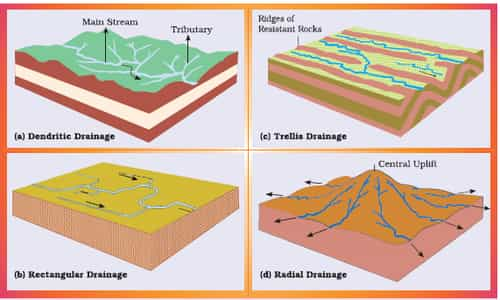
Source: NCERT
Indian Drainage System
- The drainage system of India is mainly classified into:
- Himalayan rivers
- Peninsular rivers
Himalayan River System
- The upliftment of Himalayas in different geological period resulted in the present drainage system of Himalayan rivers.
- The water divide, watershed and the channel of these rivers have changed at different times and the folding leads to the creation of many rivers.
- There are three major river systems in the Himalayas: (i) The Indus System; (ii) The Ganga System; (iii) The Brahmaputra System.
RIVER | SOURCE | MOUTH | TRIBUTARIES | DESCRIPTION |
INDUS | Near Bokhar Chu Glacier, Tibetan Plateau | Arabian Sea (near Karachi, Pakistan) | Left: Jhelum, Chenab, Sutlej, Ravi, Beas, Zanskar
Right: Shyok, Hunza, Gilgit, Kabul, Khurram, Tochi, Gomal, Viboa, Sangar | Known as Singi Khamban (Lion’s Mouth)
In India, it flows only in Jammu & Kashmir state
|
JHELUM | Verinag, J & K | R. Chenab (in Pakistan) | Right: Neelum, Sind | It passes through Srinagar and Wular Lake
|
CHENAB | Tandi, Himachal Pradesh (formed by two rivers Chandra and Bhaga) | R. Indus (in Pakistan) | Right: Marusadar river | It is also called as Chandrabhaga
It is the largest tributary of river Indus
|
RAVI | Rohtang Pass, Himachal Pradesh | R. Chenab |
|
|
SUTLEJ | Raksas Tal, near Mansarovar, Tibet | R. Chenab, Pakistan | Left: Baspa
Right: Spiti, Beas | It is known as Langchen Khambab in its source place.
It enters India through Shipki La pass
Bhakra Nangal Project is constructed across this river |
BEAS | Beas Kund, near Rohtang pass, Himachal Pradesh | R. Sutlej |
|
|
GANGA | Confluence of R. Bhagirathi and R. Alaknanda at DevPrayag | Sagar Island, Bay of Bengal (Bangladesh) | Left: Ramganga, Gomati, Gandak, Kosi, Ghaghara, Mahananda
Right: Yamuna, Son, Chambal, Betwa | Ganga is India’s largest river system |
YAMUNA | Yamunotri Glacier | R. Ganga, Allahabad (UP) | Left: Rishiganga
Right: Chambal, Betwa, Ken, Sind | It is the longest tributary of Ganga river |
CHAMBAL | Mhow, Malwa plateau | R. Yamuna, Madhya Pradesh | Left: Banas Right: Parbati, Shipra | Badland topography is an important feature of the Chambal river system |
GANDAK | Mustang, Nepal | R. Ganga, Sonpur, Bihar | Left: Trisuli
Right: Kali Gandak |
|
GHAGHARA | Mapchachungo, Tibet | R. Ganga, Bihar | Left: Rapti
Right: Sarda, Budhi Ganga |
|
KOSI | Tribenighat, Nepal | R. Ganga, Bihar |
| It is an antecedent trans-boundary river |
RAMGANGA | Pauri Garhwal, Uttarakhand | R. Ganga, Uttar Pradesh |
|
|
SON | Amarkantak Plateau | R. Ganga, Bihar (near Patna) |
| It flows northwards to reach Ganga and its largest south bank tributary |
MAHANANDA | Darjeeling Hills | R. Ganga, West Bengal |
| Last left bank tributary of Ganga |
BRAHMAPUTRA | Chemayungdung Glacier, Kailash Range, Tibet | Bay of Bengal | Left: Burhi Dihing, Dhansri, Lohit
Right: Subansri, Manas, Kameng, Sankosh | It enters India in the state of Arunachal Pradesh (near Sadiya town)
In Tibet, it is called as Tsangpo
Takes U-turn and enters India near Namcha Barwa peak
Frequent Shifting of the channel is one of its main characteristics |
Peninsular River System
- The course and channel of Peninsular rivers are evolved by passing through various geological events like subsidence, Upheaval of Himalayas, the tilt of Peninsular India
- The Western Ghats acts as a water divide between thus most of the peninsular rivers flow towards the east and few flowing through the west reaching the Arabian Sea with few exemptions which flow northwards.
- The characteristics of river channels of these rivers like the fixed course, absence of meanders, etc., indicates that these rivers are older than Himalayan rivers.
PENINSULAR RIVER | SOURCE | MOUTH | TRIBUTARIES | DESCRIPTION |
MAHANADI | Sihawa, Chattisgarh | Bay of Bengal (False Point, Odisha) | Left: Seonath, Mand, Ib
Right: Ong, Jonk, Telen | Maharashtra, Chattisgarh, Jharkhand, Odisha are its basin states |
GODAVARI | Brahmagiri Hills, Nasik, Maharashtra | Bay of Bengal, Andhra Pradesh (East Godavari district) | Left: Prahnita, Indravati
Right: Manjira, Pravara, Manair | It is called as Dakshin Ganga as this river is the largest Peninsular River |
KRISHNA | Mahabaleshwar, Maharashtra | Krishna district, Andhra Pradesh, Bay of Bengal | Left: Bhima, Musi, Munneru
Right: Tungabhadra, Koyna, Dudhganga, Ghataprabha |
|
CAUVERY | Brahmagiri Hills, Karnataka | Poompuhar, Tamil Nadu, Bay of Bengal | Left: Hemavathi, Arkavathy
Right: Kabini, Bhavani, Noyyal, Amaravati | This river receives rainfall from both south-west and north-east monsoon |
NARMADA | Amarkantak Hills, Madhya Pradesh | Gulf of Khambat, Arabian Sea | Left: Tawa, Shakkar
Right: Hiran, Kolar, Dindori | Known for Marble Rocks (Jabalpur, MP) and falls
West flowing river and flows through a rift valley |
TAPI | Betul District, Madhya Pradesh | Gulf of Khambat, Surat, Arabian Sea |
| West flowing river |
Comparison between Himalayan and the Peninsular Rivers of India
S. No. | Aspect | Himalayan River | Peninsular River |
1. | Place of origin | Himalayan mountain covered with glaciers | Peninsular plateau and central highland |
2. | Nature of flow | Perennial; receive water from the glacier and rainfall | Seasonal; dependent on monsoon rainfall |
3. | Type of drainage | Antecedent and consequent leading to the dendritic pattern in plains | Superimposed, rejuvenated resulting in trellis, radial and rectangular patterns |
4. | Nature of river | Long course, flowing through the rugged mountains experiencing headward erosion and river capturing; In plains meandering and shifting of course | Smaller, the fixed course with well-adjusted valleys |
5. | Catchment area | Very large basins | Relatively smaller basin |
6. | Age of the river | Young and youthful, active and deepening in the valleys | Old rivers with the graded profile, and have almost reached their base levels |
Source: NCERT


Comments
write a comment